- Beranda
- Komunitas
- News
- Berita dan Politik
Tropical Cyclone Seroja forecast to reach land as a category two
TS
mabdulkarim
Tropical Cyclone Seroja forecast to reach land as a category two
Tropical Cyclone Seroja forecast to reach land as a category two, bringing destructive winds
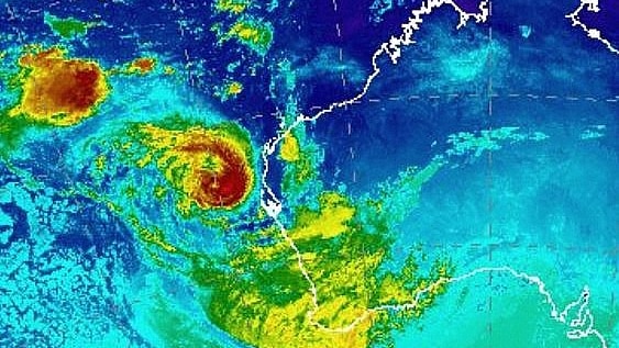
A red alert has been issued for people between Carnarvon and Kalbarri to shelter immediately, as Tropical Cyclone Seroja accelerates towards Western Australia's coast.
Key points:
Cyclone Seroja is forecast to cross the WA coast tonight
Gusts of up to 155km/hr are expected at the cyclone's peak
Flash flooding is forecast in some areas due to intense rainfall
The Bureau of Meteorology said the alert does not include the Carnarvon and Kalbarri townsites.
Evacuation centres have opened in Port Denison, Carnarvon and Denham ahead of Cyclone Seroja, which is expected to make landfall this evening.
The cyclone, which is currently a category two system, is forecast to bring destructive winds and possible flash flooding to the coast this afternoon.
A yellow alert is in place for people in or near Minilya Roadhouse to Carnarvon inclusive, and from Kalbarri to Lancelin inclusive.
It extends inland to include the shires of Northampton, Chapman Valley, Morawa, Greater Geraldton, Mingenew, Three Springs and Perenjori, and the townsites of Mullewa, Coorow and Carnamah.
What to do during a cyclone
Cyclones have the potential to threaten lives and cause large-scale destruction. Find out how to be prepared.
The Department of Communities has asked some residents in Denham to evacuate.
Tropical Cyclone Seroja may intensify to a category three system, but is forecast to drop to a category two before it crosses the coast.
Gusts of up to 155km/hr forecast
Bureau of Meteorology WA manager James Ashley said it was rare for a cyclone to travel as far south as Denham and Geraldton.
Strong wind gusts and rain are expected to begin in the Shark Bay area early this afternoon, reaching Kalbarri between 4:00pm and 5:00pm.
"People in coastal paths — particularly in that Shark Bay, Kalbarri area — should prepare for the onset of a storm surge as the system crosses the coast, which is the piling up of water in the onshore flow associated with the system," Mr Ashley said.
"It can push the ocean across low-lying coastal areas and produce flooding issues."
The system is expected to bring damaging winds of up to 155 kilometres per hour at the cyclone's centre, along with 50 to 100 millimetres of rain.
Mr Ashley said the worst conditions are expected to last for about three hours at any given location.
The northern side of the cyclone's track will bear the brunt of dangerous winds and heavy rain, he added.
"Because it's moving so fast, the onset of these conditions will be quite sudden for people," Mr Ashley said.
"It may not look too bad at a certain place, but people are warned that these conditions can deteriorate very rapidly because the system is moving so quickly."
Gusts of up to 100 kilometres an hour are likely between Minilya Roadhouse and Kalbarri during the afternoon.
Ex-Tropical Cyclone Odette weakened overnight, and is set to weaken further after making contact with Cyclone Seroja.
https://www.abc.net.au/news/2021-04-11/wa-towns-prepare-for-cyclone-seroja-to-bring-destructive-winds/100061352
Topan Seroja mulai menyerang Australia
areszzjay memberi reputasi
-1
371
0

Komentar yang asik ya
Komentar yang asik ya
Komunitas Pilihan