- Beranda
- Komunitas
- Entertainment
- Lounge Pictures
Kota Pempek in English ... :D
TS
penggemarpempek
Kota Pempek in English ... :D
gan, ada website baru nih. website tentang palembang dalam bahasa inggris. bagus nih buat promosi kota palembang ke dunia International. bakalan makin banyak bule' dateng nih ke Palembang. Bule' makan pempek

nih website nya, bagi temen2 yang berkenan tolong bantu promosiin ya. banyak sejarah dan foto-foto seputar palembang nih
http://itspalembang.com/

ini beberapa tempat wisata yang sering dikunjungi di Palembang gan
Ampera

Ampera bridge is one of famous bridge in Indonesia. It is located in Palembang, South Sumatra, Indonesia. It is used to conecting between seberang ulu and seberang ilir which separated by musi river.
Ampera bridge was started to build in 1962 and finished in 1965. initially the bridge was named Bung Karno bridge. Bung Karno was a presiden of Indonesia who fight for the will of the people to build the bridge. And at that time ampera bridge was the longest bridge in south east asia. In 1966 when political upheaval was happen in indonesia, Soekarno began to be hated for his policies were not good for Indonesian. Because of that the name of bridge was canged become Ampera bridge. Ampera was an abbreviation of the “AManat PEnderitaan Rakyat”.
In the begining, the center side of ampera bridge can be lifted 10 meter when big ship want to passing the bridge and would take 30 minute. since 1970, The official reason for this was that the 30 minutes needed to raise the bridge was causing unacceptable delays, and that in any case silting of the river had made it impassable for large ships. However, according to architect Wiratman, who acted as a consultant before the construction, the design of the bridge was flawed from the outset because of the soft mud on which it was built. He maintains that his concerns were ignored for political reasons, and that as the towers’ foundations shifted, the bridge deformed to the extent that it could no longer be opened. The ballast weights needed to balance the wight of the bridge were removed in 1990 to prevent possible accidents were they to fall
Benteng Kuto Besak

Benteng kuto besak was constructed for 17 years, from 1780 to 1797. It was officially used on Monday,21 february 1797. The idea of the building construction came from sultan mahmud badaruddin I (1724-1758). He built the building and the supervision of the construction was entrusted to Chinese.
Benteng kuto besak is 288.75m long, 183.74 wide, 9.99 m high (30ft), and 1.99 m thick (60ft). there is an entrance in each corner. The one in the northwest has a different shape from the other three. The other three same entrances represent the typical characteristic of benteng kuto besak. In the east, south, and west sides are entrance to the fortess. The main entrance facing the musi river is called lawang kuto. The other entrances are called lawang buritan (back doors).
Benteng kuto besak is one of the prides of Palembang community because it was built at the expense of the community themselves in order to defend from the attack of their enemies. What is more, the name is purely derived from Indonesia
Benteng kuto besak is located on the banks of the Musi river and faced to the Ampera bridge, this fortress is one of the heritage building of darussalam palembang sultanate. the building was built for 17 years starting in 1780 and finished on monday, february 21, 1797
Benteng kuto besak is one of famous place in palembang. BKB is also in strategic place, because it’s near from Masjid Agung, Bundaran air pancur, and also 16 ilir Tradisional Market. People ussually come to BKB in the afternoon until evening. People can see ampera, musi river and many kind of ship from BKB’s yard. In BKB’s yard there are also so many people sell souvernir and tradisional food like “mie tektek, kerak telor, kepiting goreng, etc”.
Stadion kebanggaan Palembang (kandang Sriwijaya FC)
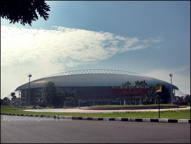
Sriwijaya Sports Stadium
The stadium started to be built on January 23rd, 2001 as one of the games during Sports Week (PON) XVI when South Sumatera was designated as the organizers. The stadium is also called Jakabaring Stadium, which is the third largest multi-purpose stadium in Indonesia after The Bung Karno Stadium in Jakarta and Palaran Stadium in Samarinda.
The stadium has around 40 hectares of land area and can seat up to 36.000 to 40.000 people with 4 terraced stands (A, B, C, and D) which surrounds the field. Stadium roof shape is a symbol of Sriwijaya triumph in the field of maritime symbolized by the shape of a boat in full sail. This stadium is existing now and was established to foster closer relationship among countries and the home of Indonesian Footbal Club, Sriwijaya FC.
Source : Dinas Provinsi Sumatera Selatan – City Guide South Sumatera Highlight
Monpera

Monpera is located in the center of Palembang City, exactly in the right side in Masjid Agung. This area used to be battle field five day five night in Palembang when Agresi Militer Belanda attact. And to remind that tragedy so that to built it. The laying of the comerstone and the pole were conducted on August 17th 1945. It was officially announced on Feb 23rd by Menko Kesra Alamsyah Ratu, Prawira Negara.
In this monument, there are many collection of weapon used during by Indonesia army to fight the colonial, there are important document, and the other history things, and kept safety in this monument and there is photo of important moment will connected in the battle.
Source: Guide Book of South Sumatera – Dinas Kebudayaan dan Pariwisata Sumatera Selatan
Museum Sultan Mahmud Badarudin II

The area of the museum used to be the location of the benteng lamo the palace of sultan Mahmud badaruddin jayo wikramo or sultan mahud badarrudin I (1724-1758) stood.
In 1821 th palace was attacked by the dutch military. On 7 october 1823 a dutch commissioner, J.L. van seven house , instructed his men to totally demolish the palace to eliminate the greateness of the Palembang sultannate. He did this as a revenge on the burning of sungai loji by sultan Mahmud badaruddin I in 1811 . the building was completed in 1825 and became the offices of the commissariat of the netherland east indies and the resident for South Sumatera area.
From 1942 to 1945 the building was occupied by the Japanese. After the proclamation of the independence of the Republic of Indonesia, the building was under the control of the Indonesian Government. In 1949, it became the office of Toritoriun II Sriwijaya. From 1960 to 1974 it was used by Resimen Induk IV Sriwijaya.
The 1988 survey conducted by the Team of National Archaeology found a brick foundation of Kuto Lamo on the burnt logs in the area. According to the calculation, the building of Benteng Kuto Lamo in the era of Sultan Mahmud Badaruddin I was officially occupied on Monday, September 29th, 1737. Thus, the age of the logs must have been more than that of the building.
The name of Sultan Mahmud Badaruddin is use to remember and appreciate this service.
Source: Dinas Pariwisata dan Kebudayaan Kota Palembang – Selamat Datang di Palembang, Kota Wisata Sungai (Welcome to Palembang, River Tourism City)
masih banyak lagi gan peninggalan-peninggalan bersejarah dari kota palembang. tolong bantu promosi website nya yaa biar websitenya bisa terus berkembang menjadi website yang dapat membantu mendatangkan wisatawan ke Indonesia")
makasih ya gan sudah baca trit ini")
jgn lupa mampir ke http://itspalembang.com/
nih website nya, bagi temen2 yang berkenan tolong bantu promosiin ya. banyak sejarah dan foto-foto seputar palembang nih
http://itspalembang.com/
ini beberapa tempat wisata yang sering dikunjungi di Palembang gan
Ampera
Spoiler for ampera:
Ampera bridge is one of famous bridge in Indonesia. It is located in Palembang, South Sumatra, Indonesia. It is used to conecting between seberang ulu and seberang ilir which separated by musi river.
Ampera bridge was started to build in 1962 and finished in 1965. initially the bridge was named Bung Karno bridge. Bung Karno was a presiden of Indonesia who fight for the will of the people to build the bridge. And at that time ampera bridge was the longest bridge in south east asia. In 1966 when political upheaval was happen in indonesia, Soekarno began to be hated for his policies were not good for Indonesian. Because of that the name of bridge was canged become Ampera bridge. Ampera was an abbreviation of the “AManat PEnderitaan Rakyat”.
In the begining, the center side of ampera bridge can be lifted 10 meter when big ship want to passing the bridge and would take 30 minute. since 1970, The official reason for this was that the 30 minutes needed to raise the bridge was causing unacceptable delays, and that in any case silting of the river had made it impassable for large ships. However, according to architect Wiratman, who acted as a consultant before the construction, the design of the bridge was flawed from the outset because of the soft mud on which it was built. He maintains that his concerns were ignored for political reasons, and that as the towers’ foundations shifted, the bridge deformed to the extent that it could no longer be opened. The ballast weights needed to balance the wight of the bridge were removed in 1990 to prevent possible accidents were they to fall
Benteng Kuto Besak
Spoiler for bkb:
Benteng kuto besak was constructed for 17 years, from 1780 to 1797. It was officially used on Monday,21 february 1797. The idea of the building construction came from sultan mahmud badaruddin I (1724-1758). He built the building and the supervision of the construction was entrusted to Chinese.
Benteng kuto besak is 288.75m long, 183.74 wide, 9.99 m high (30ft), and 1.99 m thick (60ft). there is an entrance in each corner. The one in the northwest has a different shape from the other three. The other three same entrances represent the typical characteristic of benteng kuto besak. In the east, south, and west sides are entrance to the fortess. The main entrance facing the musi river is called lawang kuto. The other entrances are called lawang buritan (back doors).
Benteng kuto besak is one of the prides of Palembang community because it was built at the expense of the community themselves in order to defend from the attack of their enemies. What is more, the name is purely derived from Indonesia
Benteng kuto besak is located on the banks of the Musi river and faced to the Ampera bridge, this fortress is one of the heritage building of darussalam palembang sultanate. the building was built for 17 years starting in 1780 and finished on monday, february 21, 1797
Benteng kuto besak is one of famous place in palembang. BKB is also in strategic place, because it’s near from Masjid Agung, Bundaran air pancur, and also 16 ilir Tradisional Market. People ussually come to BKB in the afternoon until evening. People can see ampera, musi river and many kind of ship from BKB’s yard. In BKB’s yard there are also so many people sell souvernir and tradisional food like “mie tektek, kerak telor, kepiting goreng, etc”.
Stadion kebanggaan Palembang (kandang Sriwijaya FC)
Spoiler for jakabaring:
Sriwijaya Sports Stadium
The stadium started to be built on January 23rd, 2001 as one of the games during Sports Week (PON) XVI when South Sumatera was designated as the organizers. The stadium is also called Jakabaring Stadium, which is the third largest multi-purpose stadium in Indonesia after The Bung Karno Stadium in Jakarta and Palaran Stadium in Samarinda.
The stadium has around 40 hectares of land area and can seat up to 36.000 to 40.000 people with 4 terraced stands (A, B, C, and D) which surrounds the field. Stadium roof shape is a symbol of Sriwijaya triumph in the field of maritime symbolized by the shape of a boat in full sail. This stadium is existing now and was established to foster closer relationship among countries and the home of Indonesian Footbal Club, Sriwijaya FC.
Source : Dinas Provinsi Sumatera Selatan – City Guide South Sumatera Highlight
Monpera
Spoiler for monpera:
Monpera is located in the center of Palembang City, exactly in the right side in Masjid Agung. This area used to be battle field five day five night in Palembang when Agresi Militer Belanda attact. And to remind that tragedy so that to built it. The laying of the comerstone and the pole were conducted on August 17th 1945. It was officially announced on Feb 23rd by Menko Kesra Alamsyah Ratu, Prawira Negara.
In this monument, there are many collection of weapon used during by Indonesia army to fight the colonial, there are important document, and the other history things, and kept safety in this monument and there is photo of important moment will connected in the battle.
Source: Guide Book of South Sumatera – Dinas Kebudayaan dan Pariwisata Sumatera Selatan
Museum Sultan Mahmud Badarudin II
Spoiler for museum:
The area of the museum used to be the location of the benteng lamo the palace of sultan Mahmud badaruddin jayo wikramo or sultan mahud badarrudin I (1724-1758) stood.
In 1821 th palace was attacked by the dutch military. On 7 october 1823 a dutch commissioner, J.L. van seven house , instructed his men to totally demolish the palace to eliminate the greateness of the Palembang sultannate. He did this as a revenge on the burning of sungai loji by sultan Mahmud badaruddin I in 1811 . the building was completed in 1825 and became the offices of the commissariat of the netherland east indies and the resident for South Sumatera area.
From 1942 to 1945 the building was occupied by the Japanese. After the proclamation of the independence of the Republic of Indonesia, the building was under the control of the Indonesian Government. In 1949, it became the office of Toritoriun II Sriwijaya. From 1960 to 1974 it was used by Resimen Induk IV Sriwijaya.
The 1988 survey conducted by the Team of National Archaeology found a brick foundation of Kuto Lamo on the burnt logs in the area. According to the calculation, the building of Benteng Kuto Lamo in the era of Sultan Mahmud Badaruddin I was officially occupied on Monday, September 29th, 1737. Thus, the age of the logs must have been more than that of the building.
The name of Sultan Mahmud Badaruddin is use to remember and appreciate this service.
Source: Dinas Pariwisata dan Kebudayaan Kota Palembang – Selamat Datang di Palembang, Kota Wisata Sungai (Welcome to Palembang, River Tourism City)
masih banyak lagi gan peninggalan-peninggalan bersejarah dari kota palembang. tolong bantu promosi website nya yaa biar websitenya bisa terus berkembang menjadi website yang dapat membantu mendatangkan wisatawan ke Indonesia
makasih ya gan sudah baca trit ini
jgn lupa mampir ke http://itspalembang.com/
Diubah oleh penggemarpempek 26-06-2013 10:45
0
19.6K
100

Komentar yang asik ya
Urutan
Terbaru
Terlama
Komentar yang asik ya
Komunitas Pilihan